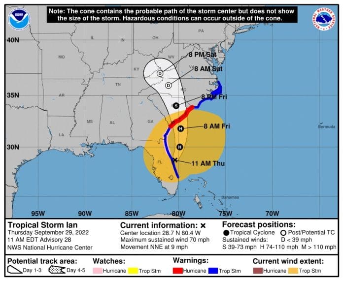
At 1100 AM EDT, the center of Tropical Storm Ian was located about 25 miles north-northeast of Cape Canaveral, Florida. Ian is moving toward the north-northeast near 9 mph (15 km/h). A turn toward the north is expected late today, followed by a turn toward the north-northwest with an increase in forward speed Friday night. On the forecast track, Ian will approach the coast of South Carolina on Friday. The center will move farther inland across the Carolinas Friday night and Saturday.
Maximum sustained winds have increased to near 70 mph (110 km/h) with higher gusts. Ian is expected to become a hurricane again this evening and make landfall as a hurricane on Friday, with rapid weakening forecast after landfall.
Ian is a large cyclone. Tropical-storm-force winds extend outward up to 415 miles (665 km) from the center. A NOAA CMAN station at the Saint Johns County pier in Saint Augustine Beach recently reported a sustained wind of 53 mph (85 km/h) and a gust of 61 mph (98 km/h).
The estimated minimum central pressure is 987 mb (29.15 inches).
Visit the National Hurricane Center website at hurricanes.gov for additional forecast information on Ian.
For more I-95 information, visit www.i95exitguide.com, the Internet’s largest and most complete website devoted to America’s Interstate Main Street. Detailed exit service listings… discount lodging, camping, food, gas and more for every exit from Maine to Florida!
Traveling another route? Visit our growing family of exit guides: I-4 Exit Guide, I-5 Exit Guide, I-10 Exit Guide , and I-75 Exit Guide


